MacDonell, John. Description of Lake Athabasca and the Chipweans, ca. 1805 and Journal of a Voyage from Lachine to Fort River Qu'Appelle, 1793. An electronic transcription. MFTP #0005
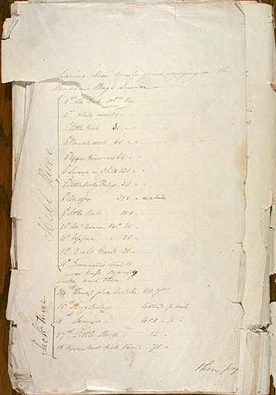
having been twenty years voyaging in the Hudson's Bay's Service[.]
Hill River |
1st The Rock |
10 yds long |
2nd White mud |
50 [yds long] |
|
3rd Little Rock |
30 [yds long] |
|
4th Burnt wood |
60 [yds long] |
|
5th Upper Burnt wood |
60 [yds long] |
|
6th Swamp in ye hill |
120 [yds long] |
|
7th Little Rocky Portage |
50 [yds long] |
|
8th Mossy |
350 [yds long] viz ¼ mile |
|
9th Little Rock |
100 [yds long] |
|
10th Mr Thomson's Port |
50 [yds long] |
|
11th Upper [Port] |
50 [yds long] |
|
12th D__l's Creek |
20 [yds long] |
|
13th Grounwater's Island |
15 [yds long] |
now Pass swampy Lake and then
Jack River |
14th Handg place JackRe. |
130 yds |
15th Long Portage |
400 [yds] ¼ mile |
|
16th Swampy [Portage] |
400 [yds] ¼ [mile] |
|
17th Little Rock [Portage] |
12 [yds] |
|
18 Upper most Jack River |
70 [yds] |
then pass
[107]
L E G E N D :
in red , modifications made by the editor(s).
in lavender , modifications made by the assumed author(s).