MacDonell, John. Description of Lake Athabasca and the Chipweans, ca. 1805 and Journal of a Voyage from Lachine to Fort River Qu'Appelle, 1793. An electronic transcription. MFTP #0005
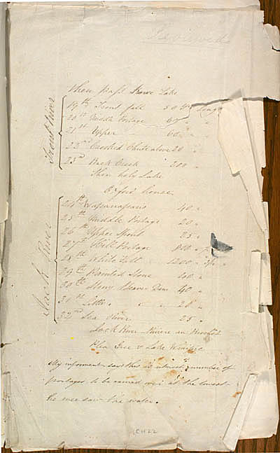
then pass Knee Lake
Trout River |
19th Trout fall |
50 yds Long |
20th Middle Portage |
60 [yds Long] |
|
21st Upper Portage |
60 [yds Long] |
|
22nd Crooked Chute above |
20 [yds Long] |
|
23rd Back Creek |
200 [yds Long] |
Then holy Lake
Oxford house
Jack River |
24th Wapanassans |
40 [yds Long] |
25th Middle Portage |
20 [yds Long] |
|
26th Upper Spout |
25 [yds Long] |
|
27th Hill Portage |
800 [yds Long] ½ mile |
|
28th White Fall |
1200 [yds Long] ¾ mile |
|
29th Painted Stone |
40 [yds Long] |
|
30th Stony Beaver Dam |
40 [yds Long] |
|
31st Little [Beaver Dam] |
20 [yds Long] |
|
32nd Sea River |
25 [yds Long] |
Jack River-Rivière au Brochêt
Plea Gree & Lake Winipie
My informent says this is utmost number of portages to be carried over at the lowest he ever saw the water.
[108]
L E G E N D :
in red , modifications made by the editor(s).
in lavender , modifications made by the assumed author(s).